Hurricane Joaquin intensifies near Bahamas, East Coast possibly in the path
By
Brian McNoldy
and Angela
Fritz September 30 at 1:47 PM

Hurricane Joaquin is forecast to intensify as it tracks north out of the Bahamas and toward the East Coast over the next few days. (NASA)
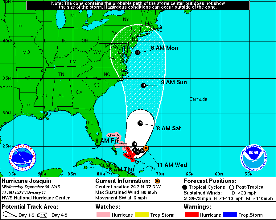
Hurricane Joaquin rapidly intensified overnight and is now a Category 1 tracking west toward the Bahamas. Though there continues to be a high amount of uncertainty in the forecast, Hurricane Joaquin could track toward the East Coast this weekend, which is now in the cone of the National Hurricane Center forecast.
At 2 p.m. Wednesday, Hurricane Joaquin had sustained winds of 85 mph and a central pressure of 968 millibars. Further intensification is expected over the next three days; the National Hurricane Center is forecasting Joaquin strengthen into a Category 3 with winds of 115 mph on Saturday as it tracks north toward the East Coast, eventually weakening before any potential landfall.
Watch
Video:
[What Hurricane Joaquin might mean for the D.C. region]
Hurricane warnings are in effect for the central Bahamas, with hurricane watches extending to the western Bahamas.
Regardless of an exact track, moisture associated with Joaquin will get pulled into an advancing low pressure and almost certainly deliver dangerous amounts of rain over the eastern U.S., from the Carolinas to Maine.

Joaquin has the potential to be a very significant storm for the mid-Atlantic and northeastern states. Heavy rain will be the first threat to the region on Thursday and Friday. The latest guidance from the National Weather Service includes an enormous swath of rainfall totals in excess of 6 inches over the coming week, with as much as 10 inches falling on the Virginia, Maryland and Delaware coasts.
By Saturday, coastal erosion and storm surge flooding could become a huge problem starting in the Carolinas and working its way up to New England by Sunday.
[Possible impacts from Hurricane Joaquin on the D.C. region]
The most recent wave forecast from NOAA shows significant heights higher than 30 or 40 feet on Sunday — a very ominous scenario. Even if the storm center remains offshore, or it begins to transition to a non-tropical cyclone, strong onshore winds will generate a substantial storm surge flooding along the coast, particularly during the regular astronomical high tides.

Over the past 24 hours, the vertical wind shear that was keeping Joaquin at bay has gradually decreased, and the storm was quick to respond. The peak winds increased from 40 mph on Tuesday morning to 80 mph on Wednesday morning. The very warm ocean water under it is also undoubtedly fueling the hurricane. Environmental conditions are expected to remain favorable for Joaquin to intensify until Saturday, with a window for rapid intensification now through Friday.
Joaquin has been moving slowly and is forecast to drift to the southwest for another two days before getting picked up by the trough moving over the East Coast. At that point Hurricane Joaquin will head north, but there is great uncertainty in the details of how that will happen.
[Interactive infographic: Billion-dollar weather disasters since 1980]
Some models suggest Joaquin will turn quickly to the north and then curve toward the East Coast, while others push the hurricane out into the Atlantic and away from land.The uncertainty in track forecast right now cannot be understated, and it is not even represented well by the official track forecast by the National Hurricane Center. Unfortunately in this situation, the spread in the forecast models is far greater in size than the cone of uncertainty in the official forecast.

A selection of deterministic dynamical models (left) and the GFS ensemble (right). (UAlbany and NOAA)

Brian
McNoldy works in cyclone research at the University of Miami’s
world-renowned Rosenstiel School of Marine and Atmospheric Science
(RSMAS). His website hosted at RSMAS is also quite popular during
hurricane season.

Angela Fritz is an atmospheric scientist and The Post's deputy weather editor.
https://www.washingtonpost.com/blogs/capital-weather-gang/wp/2015/09/30/hurricane-joaquin-intensifies-near-bahamas-east-coast-possibly-in-the-path/


2 comments:
I'm sure, HAARP will have fun with this one.
They should have said, Madonna goes to Washington, Madison Square Garden and Philadelphia.
Pope goes to Washington, Madison Square Garden and Philadelphia. gives mass
Joaquin goes to Washington, Madison Square Garden and Philadelphia
Post a Comment